
Google needs to fix a serious Google Maps problem that came to light in recent days. While Maps is one of the best tools for navigating busy cities, you should think twice before following its instructions on your next hiking excursion. Reports have detailed a couple of cases in Scotland where Google Maps offered potentially fatal hiking routes to users relying on the popular navigation app to guide them. Google has already made changes to the Google Maps hiking experience for those locations and is analyzing the situation further.
Hiking Ben Navis with Google Maps
On Thursday, a report in Mountaineering Scotland said that experts advise people against following potentially fatal online routes on Britain’s highest mountain. That’s the Ben Navis peak that rises 4,500 feet above sea level.
The report said the John Muir Trust is concerned with the number of people using Google Maps for hiking. Google Maps’ directions might direct users to the car park nearest the summit. It would then indicate a route that experts describe as “highly dangerous, even for experienced climbers.”
“The problem is that Google Maps directs some visitors to the Upper Falls carpark, presumably because it is the closest carpark to the summit,” John Muir Trust’s Nevis Conservation Officer Nathan Berrie said in a statement.
“But this is NOT the correct route, and we often come across groups of inexperienced walkers heading towards Steall Falls or up the south slopes of Ben Nevis believing it is the route to the summit.”
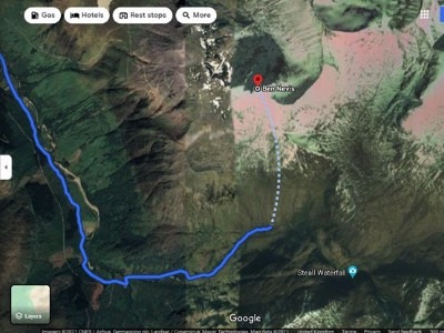
The dotted line in the image above looks like a hiking route to the summit. Following it could have disastrous consequences. Even experienced hikers might have problems with the route.
“The line goes through very steep, rocky, and pathless terrain where even in good visibility it would be challenging to find a safe line,” Heather Morning, Mountaineering Scotland’s Mountain Safety Adviser, said. “Add in low cloud and rain, and the suggested Google line is potentially fatal.”
Other peaks might have the same problem
It’s not just Ben Nevis. For hiking An Teallach with Google Maps, “a ‘walking’ route was input into the search engine, and the line offered would take people over a cliff.”
Mountaineering Scotland and John Muir Trust have appealed to Google to consult with them so the life-threatening information is removed. The Mountaineering Scotland report says that Google met their appeals with silence.
The John Muir Trust posted signs in the Ben Nevis area for inexperienced hikers, The New York Times reports. But people often ignore them.
It’s unclear whether similar issues might affect other mountains. The Times offers a similar example from New Hampshire, where mountain rescuers have saved many people who relied on their phones to navigate the mountains. The report doesn’t cite Google Maps specifically in the New Hampshire example.
Google is fixing the hiking problem
On Friday, Google told CNN that it was investigating the hiking complaints:
We built Google Maps with safety and reliability in mind, and are working quickly to investigate the routing issue on Ben Nevis and surrounding areas. In addition to using authoritative data and high definition imagery to update the map, we encourage local organizations to provide geographic information about roads and routes through our Geo Data Upload tool.
On Saturday, Google told Yahoo that it investigated the Google Maps issue for hiking Ben Navis:
We’ve investigated the issue at Ben Nevis, and have confirmed that our walking directions do not lead people through dangerous routes.
Google also said that the dotted line to the Ben Navis summit indicates the distance to the top. It’s not a walkable trail:
Our driving directions currently route people to the Nevis Gorge trailhead parking lot — the lot closest to the summit — which has prominent signs indicating that the trail is highly dangerous.
The company said that Google Maps would direct hiking parties to the mountain’s visitor center instead of the parking lot. It is also reviewing other routes near Ben Navis.
Google Maps might not be best for hiking
It’s one thing to use these apps on public roads. It’s quite different to rely on them in the wilderness. Instead of Google Maps and other navigation apps, hikers should rely on paper maps from trusted sources. They should bring compasses when out in the wild and proper gear.


