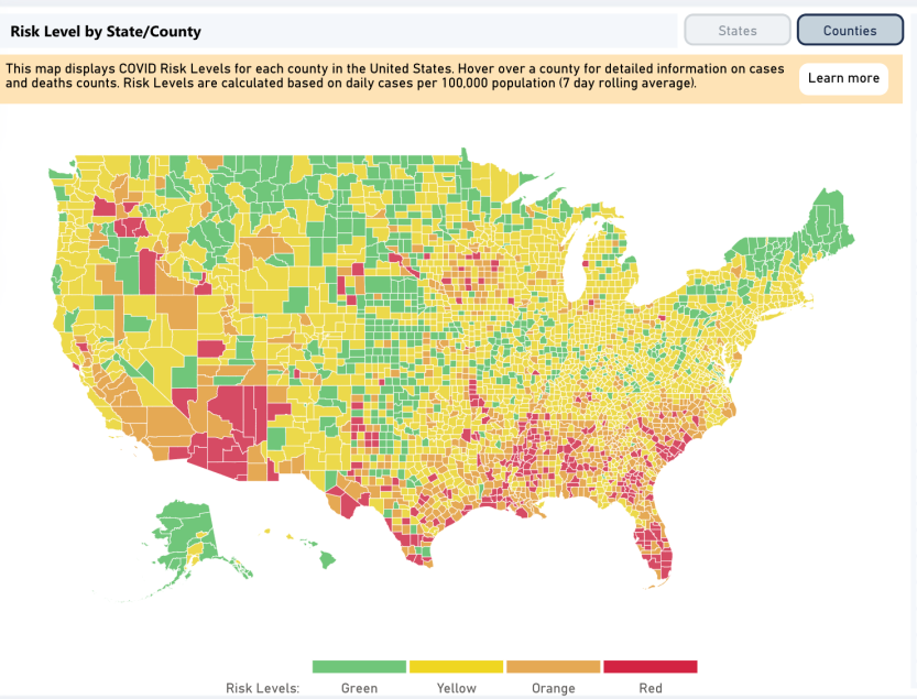
- Anyone who wants the most comprehensive US-focused coronavirus update right now could do a lot worse than to check out this new interactive map that’s been prepared by researchers and health experts, which assigns a color code based on risk down to the state and county level around the country.
- Using this map helps identify the two states where you’re statistically the most at risk of being exposed to the coronavirus at the moment: Florida and Arizona.
- Both of those states are likely to see some degree of travelers and visitors in the coming days as we head into Independence Day weekend.
No surprise, travel over the July 4th holiday weekend this year is expected to look dramatically different and unlike any historically busy fourth of July weekend in decades for a reason that should be so obvious that we don’t even need to say it.
Making this year’s travel behavior patterns look all-the-more bleak is the fact that 2019 saw such record travel activity at this time of the year — with almost “43 million person-trips” taken over the Independence Day holiday period, the second-most ever recorded at this time of the year, per Forbes. Some of you, nevertheless, will venture out this weekend, regardless. We’ve all been cooped up for months, and states and cities have gradually reopened in such a way as to teach us how to live with the coronavirus pandemic while following best practices — like wearing face masks and social-distancing. If you do plan on traveling this weekend, though, there’s at least one crucial piece of information you should be aware of.
Depending on where you’re heading, you’ll want to pay attention to a new interactive map developed in conjunction with researchers, as well as public health experts, which highlights the most several coronavirus outbreaks in the US right now. And according to this map, the places where you’re statistically the likeliest to be exposed to the coronavirus are the states of Arizona and Florida.
We’ve already noted why Florida is pretty problematic right now, such that the mayor of Miami is already on record as signaling he’s prepared to return the city to lockdown if hospitals there become overstretched. According to a tally compiled by Reuters, Florida has once again shattered its record, this time reporting more than 10,000 new coronavirus cases on Thursday — its biggest single-day total since the start of the pandemic.
Infections in Florida last month soared 168%, to more than 95,000 new cases.
Also of note, according to Reuters, is that Florida has reported more new daily coronavirus cases than any European country when the continent was dealing with the worst of its outbreak earlier this year.
The new map we mentioned above, meanwhile, was developed by Harvard Global Health Institute, working with authoritative sources including CovidActNow and Covid-Local. The risk level map shows, among other things, a county or state’s risk level (based on new daily cases) in terms of green, yellow, orange, or red colors (that’s the order of risk from low to high, ranging from green to red).
Here’s the map’s overall picture of the US right now, and you can drill down to the state and county level that you want: