Everyone Needs To Know About This New Google Maps Safety Feature
- Google announced a new Maps and Search safety feature that will make it easier to manage wildfire-related situations.
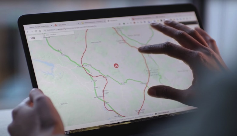
- Google Maps and Search will both display a wildfire boundary map that will be updated every hour, almost in real-time. That way, users will know what areas to avoid and receive alerts if they're in the proximity of a fire.
- The feature uses live imagery for satellites combined with Google's mapping algorithms to represent on the map the extent of a wildfire faithfully.
Google already provides SOS alerts inside its products, including Search and Maps, that cover natural disasters as well as health crises like the COVID-19 pandemic. They help to keep you safe on your trips.
This week, the company announced another safety feature that will soon be available from its apps, and it's one that everyone should be aware of. Going forward, Google will display near real-time information about wildfires, complete with an actual representation on the map of the impacted areas.
Google calls the feature "wildfire boundary map" in the official announcement, and explains it will be available in Search and Maps SOS alerts in America.
Google is relying on satellite imagery that's translated into Maps visuals to help users understand the extent of a wildfire. The approximate size and location of the fire will be displayed directly on maps, and the boundary map will be updated almost in real-time.
When people search for information about a wildfire in their area, they'll get an approximate boundary of the fire directly in Search, as well as the name and location of the fire, and news articles, and other resources that can help. The same information will be presented in Google Maps, and the navigation app will also display warnings if they're approaching a live fire. If you're exploring an area near a blaze on Google Maps, the app will issue an ambient alert to point you to the latest information.
Google explains that it's's relying on satellite information from the National Oceanic and Atmospheric Administration's (NOAA) GOES constellation of satellites and the Google Earth Engine's data analysis features. Google will update the wildfire boundary map roughly every hour, to give users accurate information about the spread of the fire.
Here's the time of imagery that satellites capture:

From Google: "Image series showing smoke from the recent Apple Fire in California, captured by GOES-17 satellite."
That information is then translated to Google Maps:
From Google: "Using data from NOAA's GOES satellites and Google Earth Engine, we create a digital polygon to represent the approximate wildfire impact area on Search and Google Maps."
Google Search and Maps will then display independent polygons for each separate fire:

Wildfire boundary map information on Google Search and Maps.
A more detailed blog post over on Medium explains all the steps involved in displaying the wildfire boundary map in near real-time inside Search and Maps.
The feature was first tested last year in a pilot program in California, where Google partnered with first responders and officials to test out the new feature and determine how to make it more useful. The clip below gives you a look at Google's new wildfire boundary map feature.