Google Maps Has An Amazing New Feature That You Probably Can't Use

Google just unveiled a fantastic feature on Google Maps, but now that it's already here, I can't even use it unless I travel to Sydney, Australia, where Google's new accessibility tools rolled out to Google Maps users.
Unlike other Google Maps features that can be rolled out more broadly, the new features will need more time to expand to more markets. That's because Google has brought Street View navigation to indoor locations, like busy train stations. That's an amazing use of Google's Street View technology, but it's not as easy to deploy as having Google's cars photograph all the streets in a city. That's why the feature is limited to Sydney, and why it will take time to cover other major markets in Australia and abroad.
Anyone who has ever tried Street View in Google Maps knows how useful the feature can be. Drop that little yellow person on a street that supports Street View, and you'll get a good look at the neighborhood. It's a great feature for exploring new cities and figuring out what your next destination looks like.
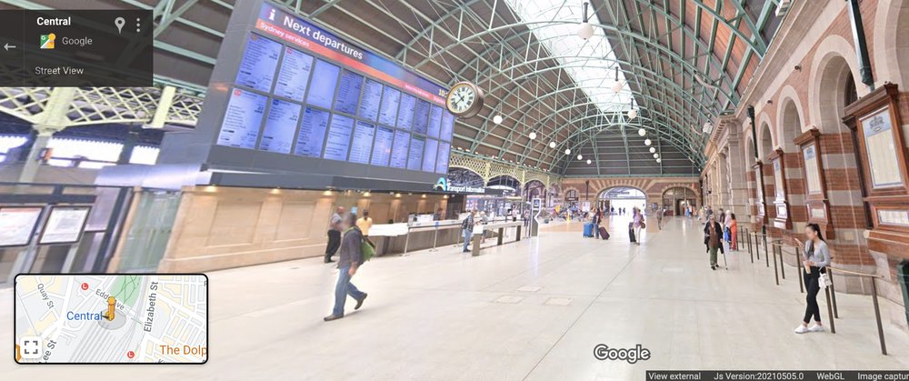
Google Maps indoor Street View mode in Sydney train stations.
But Street View would be incredibly useful in the scenario that Google describes in its blog post. Train stations, airports, malls, and other crowded indoor places can be a hassle to navigate, especially when you're on a tight schedule. Street View can help you get familiarized with the layout of the building and figure out how to get to your indoor destination as fast as possible.
Google built the new Maps accessibility feature together with Transport for NSW to help people map out their journeys inside train stations. Street View imagery will be available for 130 train stations and a dozen metro stations in Sydney. Using Street View indoors, "you'll be able to virtually navigate interactive, panoramic imagery inside Sydney stations, so you'll know your way when you get there."
This isn't the only new Google Maps accessibility feature that Google launched on Wednesday. The next one might be even easier to expand to more markets than indoor Street View support.
Google says that Maps supports detailed navigation directions for accessible routes across 70 complex train and metro stations across Sydney. "These tools allow people to find the best and most accessible entrances, exits, signage, and paths within the station and better anticipate in-transit travel times along these pathways," Google says, offering the example below.

Google Maps transit directions include accessibility details.
To take advantage of the feature, you have to tap the Directions menu after typing in a destination in Google Maps. From there, select the public transport icon and any route options that might include "wheelchair accessible," "fewer transfers," and "less walking." After tapping the chosen route, the instructions will be displayed whenever you have to navigate a complex station in Sydney on your way to your final destination.