The Google Maps Feature You Use Most Just Got A Few Exciting Updates
Google Maps is a feature-rich mapping app that lets you do more things than getting you to your destination as fast as possible. The app lets users discover everything around them, from restaurants to popular activities, offering timely information about what's going on. Google Maps integrates with various other apps, whether it's a ride-sharing app or an app that lets you pay for parking. And Google created plenty of pandemic-specific features to help users obtain information about COVID-19 testing and vaccines, as well as relevant information about business hours.
However, the main Google Maps feature remains navigation, and the navigation experience is also constantly updated. The newest such update dropped on Tuesday morning, when Google announced a few exciting updates that will impact everything about directions and navigations. Google will rely on artificial intelligence (AI) to bring a few welcome refinements to Google Maps, such as choosing the eco-friendliest transportation mode, ensuring your curbside pickup order will be ready by the time you arrive, and Live View navigation of indoor spaces.
More people have been buying products online during the pandemic than ever, and that includes groceries. Google will now offer users better shopping information to stores' Business Profiles on Maps and Search, including delivery providers, pickup and delivery windows, fees, and order minimums. The feature will be initially available in Search for Instacart, and Albertsons Cos. Maps and other partners will follow.
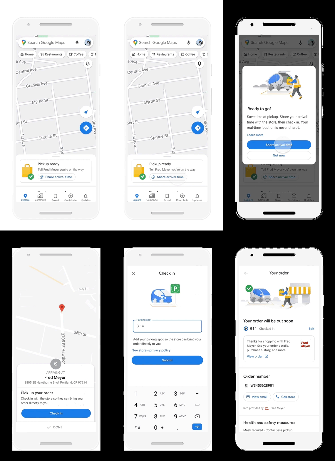
Google Maps uses AI to improve curbside pickup deliveries.
More interesting is the partnership with Fred Meyer. Google will run a pilot program in Portland, Oregon, that will involve sharing with the store your live location. After placing the order with the store's app, you can add it to Maps. The app will then notify you when it's time to leave and let you share your arrival time with the store. The ETA will be updated depending on location and traffic, so store employees can get your order ready in time of your arrival.
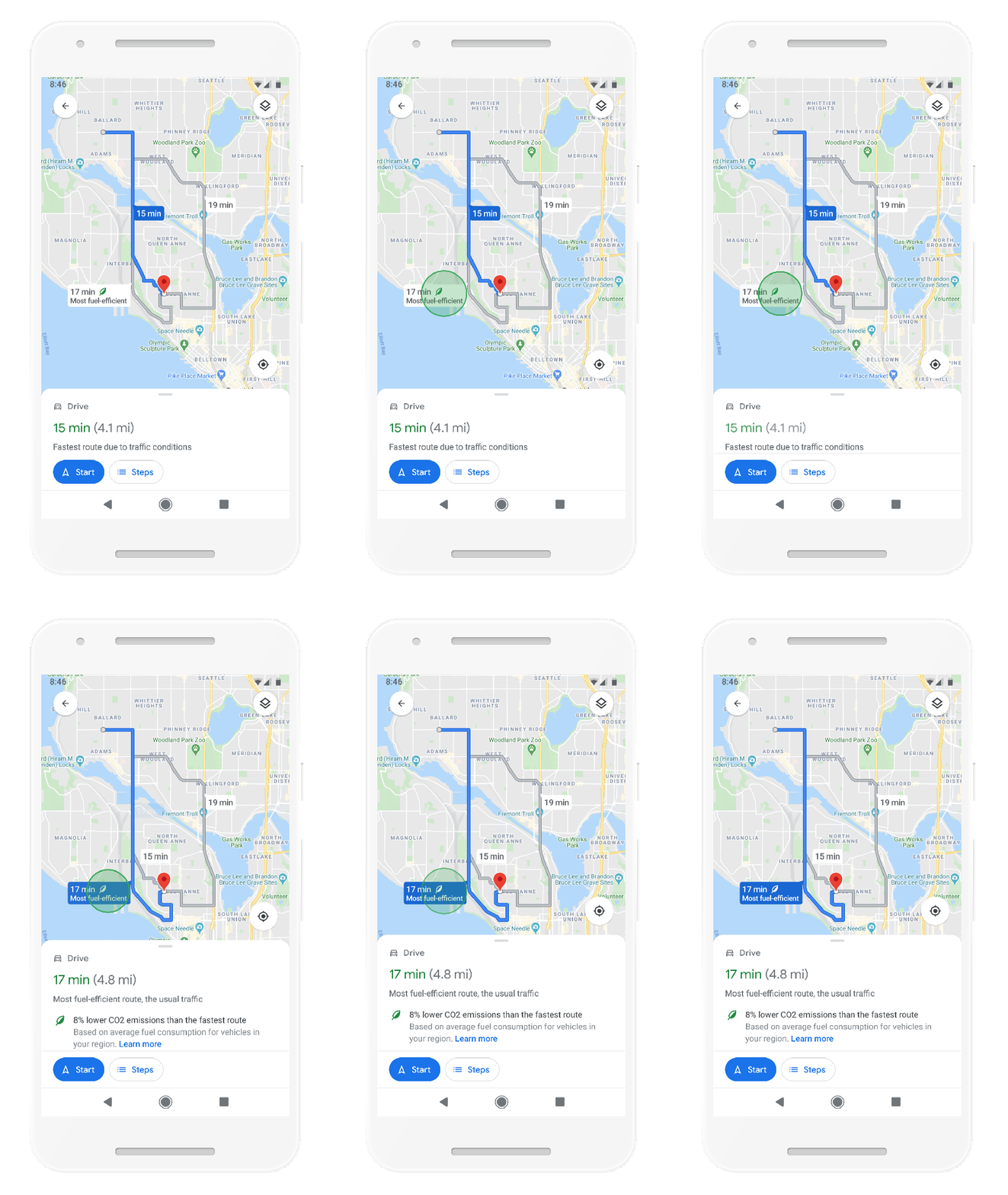
Google Maps can recommend the eco-friendliest route while setting up directions.
When it comes to planning the next drive, Google Maps will now let you choose a route that lowers fuel consumption. The app will account for road incline and traffic congestion when offering directions to your destination. Google Maps will default to the route with the lowest carbon footprint when the ETAs are similar. If the eco-friendly course takes longer, the app will show you the CO2 output for each route so you can choose. Drivers will still be able to select the speedier route, even if it consumes more fuel. These settings will be customizable in the Settings section. The feature will roll out to Android in the US first, followed by iPhone later. International Maps users will get the feature down the road.
Google Maps will also issue alerts about low emission zones. Notifications will tell you when you've arrived in one such zone. You'll know whether your car is allowed, and Google Maps will offer additional transportation modes or reroute you. The feature will roll out in several European markets first, on both Android and iOS.
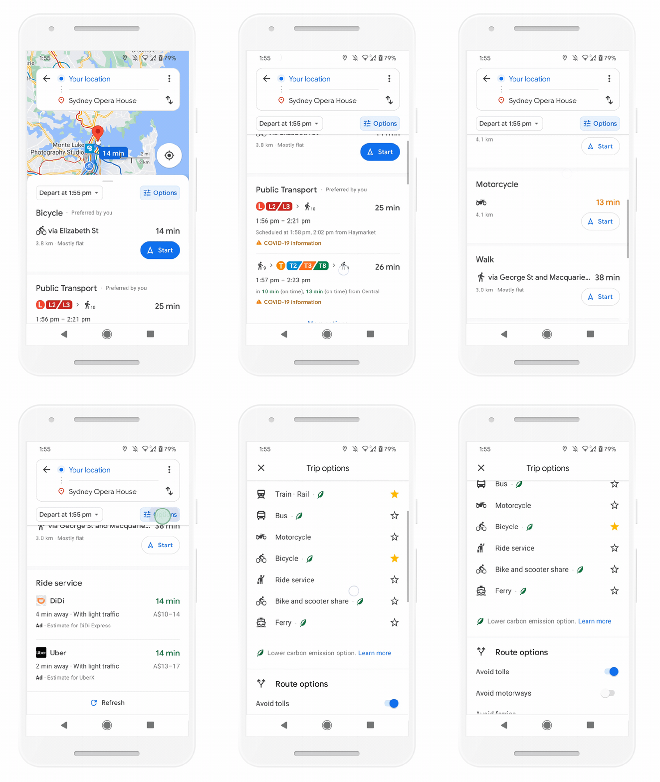
Google Maps directions show all the various transportation modes and transit options in the area in a single place.
Google's big AI changes to navigation mostly focus on sustainability, and the company has another Maps change planned that might change the way you navigate your city. Google Maps directions will show all routes and transportation modes available to your destination without you having to toggle between tabs. You'll see precisely how long it takes to drive to your destination and what public transit options are available. Maps will learn from your preferences, prioritizing some modes based on your habits or based on the popular choices in your area. The feature will be available globally on Android and iPhone.
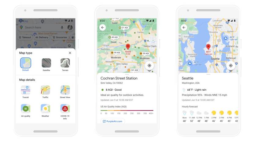
Google Maps now supports weather and air quality layers in select markets.
Maps users who prefer walking can take advantage of the new weather and air quality layers. The app will show forecasted temperature and weather conditions in the weather layer. The air quality layer tells you how healthy or unhealthy the air in your area is. The new layers will be available on iPhone and Android, with the weather layer rolling out globally. The air quality layer is coming to Australia, India, and the US in the coming months.
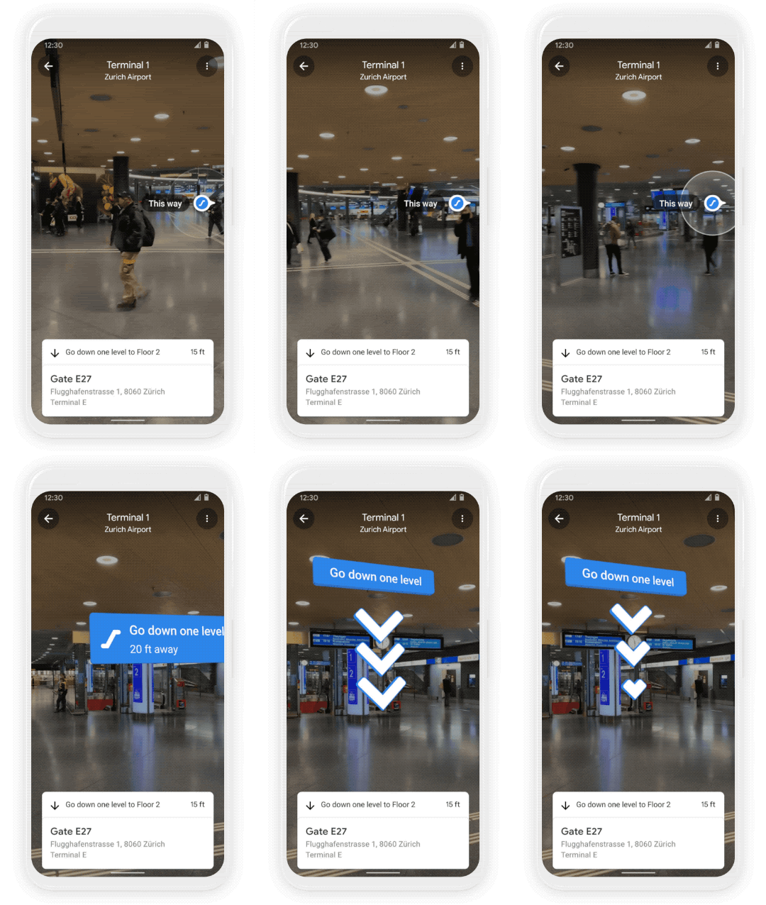
Live View works indoors in select locations, like the Zurich train station.
Finally, Google Maps is set to improve one of its most exciting features in the best possible way. Live View is a Maps mode that lets you point the phone's camera to the world while navigating it with Maps. Directions will be displayed on the screen, overlaid over images of your surroundings. Live View is a great tool to have to avoid getting lost while searching for a particular destination. The feature would be even better for navigating massive indoor spaces like airports and train stations. And that's exactly what Google is about to do. Live View will help you find the nearest elevator, escalator, gate, platform, baggage claim, check-in counters, ticket office, restrooms, ATMs, and other indoor attractions at airports, transit stations, and malls.
But the feature won't just work everywhere, as Google will have to update it with new locations gradually. Malls in Chicago, Long Island, Los Angeles, Newark, San Francisco, San Jose, and Seattle support Live View. Select airports, malls, and transit stations in Tokyo and Zurich will get it in the coming months.
