Everything You Need To Know About Tracking Hurricane Irma
Hurricane Irma, one of the most powerful Atlantic storms ever recorded, is currently on track to wreak havoc on Florida. Having already made landfall on some small islands, it's moving perilously towards the densely-populated state, where its 185mph winds would be devestating.
But we're still not certain of Irma's path. Weather forecasting is notoriously tricky to get right, even with supercomputers and some of the world's best scientists on the case. Different approaches to forecasting have led to a mess of different predicted storm paths, with the variance being the difference between a direct hit on Miami from 185mph winds, or a mildly windy day on the beach.
So if you want to keep a close eye on Hurriance Irma and understand how likely different outcomes are, here's what you need to know.
Know your models
There's a few different ways that meteorologists use to try and predict the path of a storm. Historically, the most accurate model for predicting the track of a storm is that produced by the European Center for Medium-Range Weather Forecasts, known as the "European model." It uses an array of supercomputers to model weather for the entire planet. By knowing what the weather will be like all round the world, the theory goes, it's easier to predict the path of any one particular storm. The downside to the European model is that it only runs twice a day, thanks to the amount of computational power required.
The American equivalent is called the Global Forecasting System (GFS), run by the National Weather Service. It's run four times per day at a lower resolution, and although it's not held in as high regard as the ECMWF, the timely data is still useful to forecasters.
The National Hurricane Center in Miami uses data from both models, as well as other inputs, when producing its reports. The US also has the Hurricane Weather Research and Forecasting (HWRF), which uses real-time data from aircraft and satellites to monitor changing weather conditions faster than the scientific models. The HWRF was recently key in monitoring the intensity of Hurricane Harvey.
Check the National Hurricane Center
Luckily, you don't have to weigh the pros and cons of different weather forecasts and monitoring services. The National Hurricane Center produces a number of constantly-updated maps and advisories for tracking a hurricane, and should be your first port of call for information.
It has a central page of information on Irma that provides an overview of the hurricane's current status, predicted track, and areas that should be taking action. The page also shows the most recent public advisory, forecast advisory, and forecast discussion. The public advisory is a one-page statement that tells you about the likely outcome of the storm, and what action you should take; the forecast advisory and discussion give more information and are more technical.
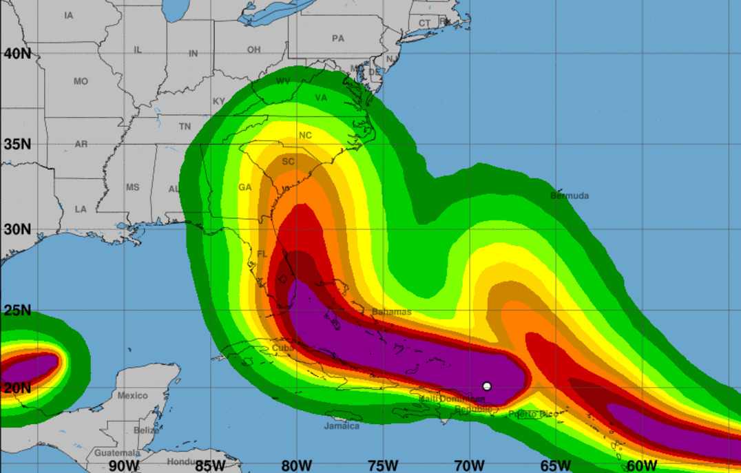
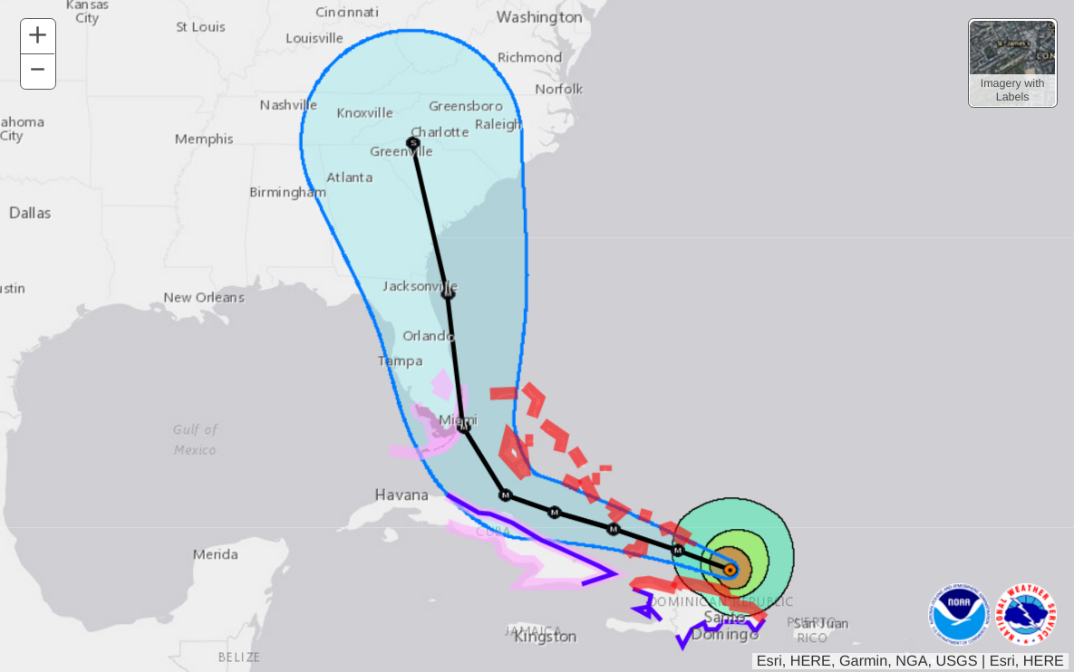
The best visual aide is the interactive warnings/cone map, which shows the current best-guess prediction for the hurricane's path. The "cone" shown on the map is where the eye of the storm is probably going to pass; anywhere within that cone is possible, with the line down the middle showing the storm's most likely path — but it's far from a guarantee. If you want to dive down further into local advisories, it links to the page for the National Weather Service's local products here.
Be wary of other forecasts
Local weather shows and cable news are liable to show a "spaghetti map" of different types of forecast showing wildly different tracks. Ars Technica did a good breakdown of the different models and how they can be produced by vastly different means. While they're useful data points for forecasters to interpret, many of the forecasts don't work well as standalone products, and imply that forecasters have no idea what's going on.
The opposite is true: weather forecasters have a good idea of how much they don't know, and the huge area covered by the NHC's cone of possibility goes to show it. Just because one archaic model shows your town being passed completely by, doesn't mean you should ignore the advisories being issued by forecasters for your local area.